We fly our spotter plane regularly during offshore season to get a visual on our local waters. We then pass along the exact GPS numbers of offshore fish schools, kelp paddies and more.
When you join FishDope you get more: more fishing reports, more hot bite GPS coordinates, more spotter plane reports, and more coverage of the Southern California fishing spots. Your small group of fishing buddies instantly transforms into an established network of commercial, professional and recreational fishermen that fish every region of the Southern California and Northern Baja Coasts.
FishDope is your competitive edge.
For $199 a year – or less than a tank of fuel for most private boats in Southern California – you gain access to the most accurate and up to date Southern California fishing reports available anywhere.
Here at Fishdope we have one purpose: to help you “Catch More fish, Burn Less Fuel”
Saving fuel may be easier than you think. Let’s say, for example, you want to get into the good yellowfin tuna fishing that is 45 miles from Point Loma, San Diego. The fish have been working up the line closer to San Diego all week. You plan your trip over the course of the workweek until finally, Friday rolls around. As you head down to the launch ramp you check Fishdope one last time and see that the bite has moved. A strong southerly flow has pushed the pocket of water that is holding the fish northwest. You write down the fishing GPS numbers. You quickly check the Southern California fishing chart interface and plan a new route, which is easy to do because the hot bite fish icon is already on the chart at the exact location where the fish are being caught. You plot your course and you are off. Instead of wasting valuable time and expensive fuel searching for the fish while you are on the water, you drive straight to them. Now you have more time to catch the fish and have burned less fuel doing it.
The daily Southern California fishing reports chart cover, Santa Barbara, Channel Islands, Catalina Island, San Clemente Island, Los Angeles, Dana Point, Oceanside, San Diego, Coronado Islands, Ensenada, San Quintin, inshore, offshore, and everywhere in between. If there is a bite going on we’ve got the dope!
Many sites offer 1 or 2 of these necessary tools but there is only one site that incorporates all of them: FishDope.
Sea Surface Temperature Charts
Sea surface temperate (SST) measurements are made by numerous satellites orbiting our Earth. We are able to make SST images available to our user’s right after they’re collected.
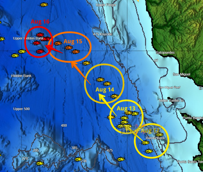
The Fishdope Hot Bite Chart is one of the most used tools for the offshore fisherman. By gathering daily fish reports from professional captains, sport boats, 6 pack and 4 pack charter boats, fly over planes, commercial fishermen, VHF and private anglers
The VHF radio is one of the tools we use to listen in on what is going on offshore. Our own “code group” of captains and fishermen we have put together call in fish reports from offshore so we can get the info in a timely manner.
Since 2008 users have won tournaments, caught new species of fish, caught more fish, saved fuel and enjoyed the daily fish reports keeping them up to date with the latest fishing bite info in Southern California.
Check out some archived daily fishing and weather reports from Fish Dope.
We keep an archive that is accessible by our subscribers. Years of fishing information at their finger tips.
Fishdope is simply the bomb. I have been fishing the coastal waters of Southern California and northern Baja for many years. I know all about the “free” internet sites, but never had much luck using just the SST's and it seemed I was always a day late for the what the fishing reports offered. Surfing 4 or 5 different websites to put the weather and fishing information together is kind of a pain. Now that I have ALL of the fish catching information on ONE SITE, it is much easier for me to put it all together and find the fish! When the chlorophyll concentrations coincide with the temp breaks, it’s a straight shot to GAME ON! I burn less fuel when I know where the fish are, and I have a lot more confidence in my ability to put fish in the boat. Add the tides, moon phase, buoy data, and what you have a great all around “friend” to help you catch fish.. and catching fish is why I go fishing! I use fishdope for every trip I make offshore.
Benny Morales - San Diego
Catch More Fish. Burn Less Fuel. Only $199 per year!

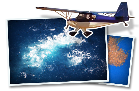 Spotter plane dope!